
Precision Aerial Surveying, Photography, and Videography
Hawaii Aerial Observation Capabilities
Honolulu Helicopter Charters provides robust aerial survey capabilities across Hawaii, leveraging rotorcraft for precise data acquisition. Our services encompass advanced applications such as magnetometer and electromagnetic surveys, LiDAR, and Geographic Information System (GIS) mapping. The helicopter's unique low-flight and hover characteristics are instrumental for detailed site assessments. Furthermore, we specialize in high-definition aerial filming services, incorporating specialized camera mounts and the option for door-off operations to facilitate professional-grade cinematography and still photography for various media projects.
Aerial
Surveys
LiDAR, GIS Maps, FLIR, HD Video & More
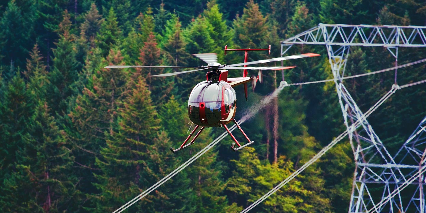
For critical infrastructure management, Honolulu Helicopter Charters provisions the precise aircraft and specialized equipment required for comprehensive pipeline surveys, rights-of-way inspections, and transmission line patrols across Hawaii. Our focus is on supporting robust monitoring programs to ensure the integrity and operational efficiency of vital assets, executed with meticulous attention to project specifications.
High Tech Results
The Top Pilots in Hawaii, Today's Technology... Maximum Results.
Call 1-866-826-4826 Now!
Honolulu Helicopter Charters provides the tools needed to complete your land surveys, utilizing the right equipment to provide the aerial photos that are often needed.
Effective aerial surveys are pivotal for streamlining rights-of-way and site inspections, gathering precise topographical data, and capturing high-definition imagery for commercial development projects throughout Hawaii. Helicopter-based surveys offer an unparalleled vantage point for meticulous terrain analysis, detecting anomalies in pipeline infrastructure, identifying critical issues with transmission lines, and conducting detailed property assessments. Honolulu Helicopter Charters develops bespoke photographic and remote sensing operational plans, meticulously tailored to maximize technical accuracy, financial efficiency, and overall project outcomes.
The inherent operational characteristics of a helicopter establish it as the definitive platform for aerial surveying. Unlike fixed-wing aircraft, which are generally restricted by FAA regulations to a minimum of 1,000 feet above obstacles, rotorcraft possess the unique capability to operate at significantly lower altitudes and maintain slower airspeeds. This enables granular inspection of challenging or hazardous terrains, providing engineers and technical teams with an otherwise unattainable perspective critical for detailed analysis and informed decision-making.
There is no better way to conduct your visual survey, animal population counts, soil drainage analysis, ROW inspections, pipeline and transmission line inspections, and geographical surveys.

LiDAR Imaging
Light Detection and Ranging, or LiDAR, is a remote sensing method used to examine and measure Hawaii topography as well as objects, like vegetation, upon it.

Infrared Imaging
Thermographic IR cameras are used to detect radiation in the long-infrared range of the electromagnetic spectrum and produce images of that radiation, called thermograms.

HD Video Gimbal Capture
Modern HD and 4K cameras can be mounted to helicopters, using the proper STCs, with a gimbal to stabilize photos & videos for detailed results.

Specialized Aerial Filming and Professional Videography Solutions
For expert camera work in the Honolulu Sky
Get a Fast, free QuoteHonolulu Aerial Cinematography
Honolulu Helicopter Charters offers comprehensive access to resources for professional-grade aerial cinematography across Hawaii. We facilitate the integration of advanced gyro-stabilized camera systems, including industry-standard platforms such as Tyler Mounts, Wesscam, Cineflex, Pictorvision, and SpaceCam, configured with high-performance cameras like Cineflex HD, RED Epic, and Arri Alexa. Our capabilities extend to supporting specialized 3D and experimental camera setups. We support all aspects of production, from air-to-air to ground-to-air compositions, ensuring precise execution of directorial and cinematographic objectives. Specializing in rotorcraft provisioning for both still and motion photography, Honolulu Helicopter Charters supports a wide array of media operations in Hawaii, including feature films, television productions, documentaries, promotional videos, commercials, aerial props, and critical logistical support for broadcast networks covering major historical and sporting events.
Call Us Today at 1-866-826-4826 for a Free Quote
Contact Us
Aerial Photos
Hand-held or Mounted OpTions in Honolulu
We will help you get the right equipment for your aerial photography project! Call 1-866-826-4826 today to get a fast, free quote.
The Most Options for Photography
The dynamic topography of Hawaii provides an unparalleled backdrop for professional aerial photography. Honolulu Helicopter Charters specializes in provisioning helicopter charters engineered to optimize image capture, allowing photographers to realize their creative vision with technical precision. We offer access to diverse rotorcraft platforms, many capable of door-off operations for direct handheld photography, and provide information on advanced gyro-stabilized camera mounts to ensure superior image stability and capture quality for critical assignments. Our commitment is to facilitate technically robust aerial imaging opportunities for discerning clients throughout the islands.
Superior Service
Every one of our customers gets a dedicated helicopter expert to assist with flight plans, tech loadouts, production logistics, project schedules, and other demands.
Over 500 Aircraft
Our network of direct air partners extends well beyond Honolulu, Hawaii. This allows us to offer a wide range of solutions for even the most sophisticated projects.
The Best Equipment
From high-tech sensors like LiDAR, FLIR, and GIS to HD cameras and movie production gimbals, we're here to make your job as easy as possible.


